UTM Coordinate Converter
... seamless user experience. The software also includes a map view, allowing you to visually confirm the location of your coordinates. Ewert Technologies has a reputation ...

GPS TrackMaker is a freeware application for creating and editing GPS waypoints, tracklogs and routes. It can transfer these items to and from more than 160 GPS models, and display a connected receiver's position on a map for real-time navigation. Users can calibrate scanned map images, create vector backgrounds, calculate track distances and speeds, and work with formats such as GPX, TXT and GTM.
| Author: | Geo Studio Technology |
| License: | Freeware |
| Price: | FREE |
| Released: | Jan 28, 2015 |
| File size: | 55.00 MB |
| Downloads: | 684 |
| Keywords: | Geo Studio Technology, x64 software, route, gps map software, map, GPS TrackMaker, gps track editor, route planning tool, waypoint manager, tracklog viewer, Windows 10 compatible, real time gps navigation, track, mapping application, GPS, Track maker, gps route planner |
| Author URL: | http://www.gpstm.com |
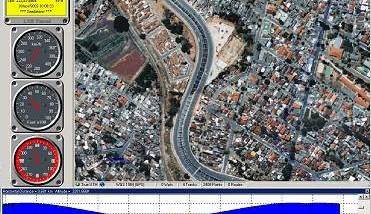

GPS TrackMaker is a desktop mapping and GPS data application for people who plan routes, manage GPS recordings or work with map images. It provides tools to create and edit waypoints, tracklogs and routes, then organize those items together on a map. The program is useful for preparing trips in advance as well as reviewing recorded journeys, with support for a broad range of GPS receivers and common navigation data formats.
The editing tools let users add waypoints, draw routes and create or modify tracklogs directly on the map. Tracklogs can be assigned names, styles and colors, making separate journeys easier to distinguish. More than 260 waypoint icons are available for marking locations, while map controls support zooming, panning and changing the display of backgrounds, grid lines and waypoint symbols. The program can calculate tracklog length and instantaneous and average speeds, which helps when examining a recorded route.
For map-based work, GPS TrackMaker can calibrate scanned images in GIF, JPG, BMP, WMF and EMF formats, allowing a picture of a map to serve as a navigable background. Multiple map images can be placed in the same workspace, and vector backgrounds can also be created. Its coordinate tools include a database of more than 280 datums and a True-Grid mode. The application can open and save GPS data in formats including TXT, GPX and GTM, and supports data from MapInfo, ArcView, Google Earth and other sources.
GPS data can be transferred between the computer and supported receivers, including waypoints, tracklogs and routes. The program recognizes more than 160 GPS models, including devices from Garmin, Magellan and Eagle. Real-time navigation displays the connected GPS position on the map, so a portable computer can be used to follow location while travelling. NMEA 0183 support also allows real-time navigation with other compatible GPS models. Maps can be printed at scale, and the interface includes options for map appearance and colored symbols.
GPS TrackMaker is freeware for Windows, with support stated for Windows 10. Its combination of receiver transfers, map-image calibration and editing tools suits recreational navigation, route preparation and GPS track review. Results depend on compatible GPS hardware and suitable map or GPS data; real-time navigation requires a connected receiver. The program also supports earlier Windows releases, while Windows 11 compatibility is not established here.