Portable MicroCity
Portable MicroCity is a lightweight geographic information system (GIS) and ... one compact application. The program supports model building with MicroCity Script. Users can write scripts to define an ...

MicroCity is a lightweight GIS and spatial modeling application for users who need to analyze geographic data or build simulations without a large, complex software suite. Alongside fundamental GIS functions, it includes libraries for network and fractal analysis, 3D work, simulation, and linear programming. MicroCity Script lets users create and run models, while downloadable modules and SAGA API compatibility extend its capabilities. Its portable design supports copying a model directory for use elsewhere.
| Author: | Sourceforge |
| License: | Freeware |
| Price: | FREE |
| Released: | Mar 14, 2018 |
| File size: | 6.83 MB |
| Downloads: | 376 |
| Keywords: | spatial simulation, analysis, x64 software, spatial analysis, saga module support, spatial simulation tool, Sourceforge, Windows 10, fractal analysis tool, microcity gis, open-source software, fractal analysis, analyze, MicroCity, gis scripting software, urban planning simulation, analyzer, spatial analysis software |
| Author URL: | https://sourceforge.net/ |
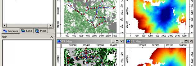



MicroCity is a lightweight GIS and spatial modeling application for users who need to analyze geographic data or build simulations without relying on a large, complex GIS package. It combines fundamental GIS functions with tools for scientific modeling, making it suitable for exploratory analysis, research, and custom workflows that involve spatial relationships.
Its built-in libraries extend the basic mapping and analysis capabilities. Network functions support work with connected spatial systems, while fractal tools allow fractal analysis of spatial patterns. Three-dimensional functions provide another way to represent or examine data, and simulation tools help users model processes. An integrated linear programming solver can be used for optimization problems. These components make MicroCity applicable to a range of analytical tasks within one environment, rather than requiring every operation to be assembled from separate software.
MicroCity also supports scripting through MicroCity Script, which users can use to define and run models. Scripts provide a repeatable way to organize analysis steps and adapt a workflow to a particular problem. The application is extensible through downloadable modules, and its use of the SAGA API allows SAGA modules to be reused. Users can customize the program and their modeling setup, while its portable design lets them copy a model directory and run it elsewhere without a conventional installation-centered workflow.
The program is intended for spatial analysis and simulation work where a compact, scriptable toolkit is useful, including scientific modeling and experiments with networks, spatial patterns, 3D data, or optimization. Its built-in functions can help keep related operations together, while scripting and modules offer options for adapting workflows beyond the core tools. MicroCity is free to use and is presented as open source, with customization permitted under its applicable agreement.
MicroCity runs on Windows systems, including Windows 10. Its small download size and low resource use make it a practical option for users seeking a modest GIS modeling tool rather than a resource-intensive suite. The available platform information includes older Windows releases as well; Windows 11 compatibility is not established here.