TimeAlbum Pro
... Pro, a cutting-edge software developed by Columbus and RouteConverter. TimeAlbum Pro is a versatile tool that allows you to organize and manage your time effectively, ...

RouteConverter converts, displays and edits GPS data for travelers, hikers, cyclists and other users working with routes and waypoints. It supports formats including GPX, KML and CSV, and shows data on an interactive map with services such as OpenStreetMap and Google Maps. Users can move route points, edit waypoint coordinates, elevation and timestamps, and calculate distance and elevation. Batch processing helps manage multiple routes. The open-source program requires Java.
| Author: | Christian Pesch |
| License: | Open Source |
| Price: | FREE |
| Released: | Jun 10, 2026 |
| File size: | 61.20 MB |
| Downloads: | 559 |
| Keywords: | gps data conversion, Convert Route, route map viewer, kml route converter, gpx file editor, Route, Route planning software, Route Converter, User-friendly interface, Offline maps availability, Map Viewer, Multi-language support, Map, Convert, gps route converter, gps waypoint editor, Christian Pesch, GPS data conversion |
| Author URL: | https://www.routeconverter.de/home/en |


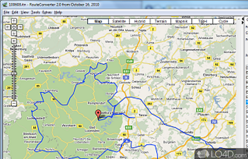


RouteConverter is a GPS data utility for travelers, outdoor enthusiasts and professionals who need to view, edit or transfer routes between mapping tools and GPS devices. It brings route and waypoint information into a map-based workspace, where users can inspect their paths and make changes before saving the data in a format suited to another application or device.
The program converts GPS files in formats such as GPX, KML and CSV. This is useful when a route created in one service needs to be opened elsewhere, or when a GPS device expects a different file type. RouteConverter can also display route data on an interactive map, including maps from OpenStreetMap and Google Maps. The map view helps users understand how a route follows roads or trails and see where waypoints sit in relation to the surrounding area.
Routes and waypoints can be adjusted directly on the map by dragging points or changing the path. Users can also edit waypoint information, including coordinates, elevation and timestamps, to correct details or tailor GPS data for a planned outing. Distance and elevation calculations provide additional context for comparing or preparing routes. Batch processing supports working with multiple routes or waypoints together, which can be useful when organizing larger collections of GPS files.
Typical uses include preparing a hiking or cycling route, reviewing a recorded journey, moving GPS data between applications, and checking or correcting waypoint details. The combination of file conversion and map-based editing lets users handle these tasks in one program rather than relying only on a separate viewer or converter. The available mapping view and route data can also help with inspecting terrain-related information before setting out.
RouteConverter is open-source software by Christian Pesch. It runs on Windows 10 and Windows 11, as well as earlier Windows versions, and requires Java. The program is also available for macOS and Linux. Its broad file-format support is intended to help users work with GPS data from different sources, though the formats available for a particular task depend on the files and devices involved.