Alternate Calculator
Alternate Calculator is a Windows desktop calculator for everyday arithmetic and a range of common ... want a focused alternative to a basic on-screen calculator, including students, home users and people handling routine ...

Metes and Bounds turns deed descriptions and survey calls into plot maps, with calculations for square feet, acres, hectares, and perimeter. It accepts line and curve data in many measurement units, checks whether a boundary closes, and calculates closure errors. Layers, automatic line labels, custom backgrounds, parcel splitting, and a Drawing Wizard support map creation. Drawings can be printed or exported as DXF, KML, and CSV, with real-world coordinate options for mapping workflows.
| Author: | Sandy Knoll Software |
| License: | Demo |
| Price: | $39.95 |
| Released: | Oct 23, 2026 |
| File size: | 44.30 MB |
| Downloads: | 568 |
| Keywords: | calculate square feet, plot map, perimeter, deed plot map, land mapping, property description software, acreage, survey map export, calculator, acreage calculator, x64 compatible, calculate acreage, real estate plotting, land survey plotting, Sandyknoll Software, boundary closure calculator, metes and bounds software, Metes and Bounds |
| Author URL: | http://www.tabberer.com/sandyknoll/more/3dmaker/anaglyph-software.html |
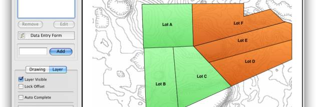

Metes and Bounds is a land-survey plotting program for turning deed descriptions and survey calls into plot maps. It is intended for surveyors, land professionals, and property owners who need to inspect boundary data, calculate parcel dimensions, or prepare a drawing for printing or use in other mapping software. The program works with straight-line and curve data and reports area in square feet, acres, and hectares, as well as perimeter distance and other measurements.
Survey calls can be entered through a data-entry form using a range of units, including feet, meters, rods, chains, varas, yards, inches, fathoms, hands, spans, and furlongs. Angles can be specified in degrees, minutes, and seconds. As calls are added, Metes and Bounds checks whether the boundary closes and calculates closure errors, helping users identify inconsistencies in the source data. When a final segment is missing, the drawing can be auto-completed; users can also enter a question mark for an unknown call and have the program determine a missing segment.
A drawing can contain multiple deed layers, either floating independently or aligned to a shared starting point. The program automatically labels lines with their lengths and calls, and can mark endpoints with information such as interior and exterior angles. Users can add custom labels, backgrounds, and X,Y points for notable land features. Backgrounds can be scaled to the plot, and a screen measuring tool estimates the distance between two points. The optional Drawing Wizard asks about the intended drawing and presets relevant values before work begins.
For further analysis and presentation, a single plot can be split into multiple parcels by hand or by selecting a starting point for an automatic division into nearby halves. The software can also create section drawings, include a call list, and prepare printouts with borders, a north arrow, and a title block. Export options include DXF, KML, and CSV, along with real-world X,Y coordinates for use with other mapping and GIS software. Users can enter a plot's point of beginning as latitude and longitude and calculate coordinates for its other endpoints; GPS waypoints are also supported.
Metes and Bounds is offered as demo software and is designed for Windows. It supports Windows 10 and Windows 11, as well as Windows 7 and Windows 8 in 32-bit and 64-bit editions. Its combination of deed plotting, closure checks, area calculations, parcel splitting, and export tools suits work ranging from checking a boundary description to producing a shareable map or printed survey drawing.